Pearl Harbor Blast Zone: Ewa Gentry New North Park Development Half A Mile From Major New Army Missile Magazine Munitions Storage Complex
I wonder how many people will want to buy a home in Gentry's North Park?

NorthPark by Gentry - https://www.google.com/maps/d/viewer?mid=1DFoL-bFw8_WH9awzEcC7mP0n7S7qU5Rf&usp=sharing
I am by no means anti-military. However I am very concerned when specifically NavFac, is running these possibly very dangerous new munitions projects under the public radar without adequate presentation and public comment period. public websites, even doing an EIS, which the Navy (NavFac) always refuses to do. It's always FONSI.
I am especially concerned that they are actually lying to the public claiming the historic 1.4 mile distance is sufficient. Even more insane is their claim that having the new Army facility about .5 miles from a packed suburban community is "safe" just because it is "inside the arc" of 1.4 miles. And don't fall for their "safe magazines" pitch. The danger and explosive arc of munitions is in effect the moment the magazine door is opened and the movement to and from the ammunition ship or sub begins. The NavFac's new Captain Meyers told Sen. Mike Gabbard:
---they use NAVSEA OP 5, Volume 1 which is loaded with references to other DoD manuals but does provide some specifics:
"The ESQD arcs for ships and vessels carrying cargo ammunition are based on the total NEW of cargo ammunition aboard plus the total NEW of the ammunition handled or staged."
"The ESQD for FBM submarines is based on the total quantity of missiles on the submarine if a hatch is open for any operation directly related to a missile.
(1) If the hatches on a fleet ballistic missile (FBM) submarine are opened for any
operation related directly to the missile (i.e., loading or maintenance), the total NEW of all missiles aboard must be applied to the pier NEW limit. (2) AE stowed outside of designated ship's magazines, launchers, or ready service lockers will be considered cargo ammunition, --etc"
I invite you to try out the very easy to use Software used to determine ESQD - (Explosives Safety Quantity Distance) United Nations ITAG (International Technical Ammunitions Guideline) which scales to net explosives input: https://www.un.org/disarmament/un-saferguard/map/
for Pearl Harbor West Loch use these coordinates:
Latitude: 21.345589355722055
Longitude: -158.01463734402498
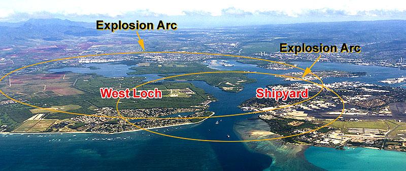
The blast arcs in my testimony are using Army DoD MOTSU criteria
Also look at the well reported meetings with the Cape Fear community.
Last year, after initiating the JLUS, the military terminal shared the radius of its previously undisclosed blast safety arcs.
https://capefearcog.org/wp-content/uploads/2018/11/November-Policy-Committee_web.pdf
The Army West Loch munitions facility plans to bring in huge ammunition ships. That buried in the bottom of their EA.
Local news coverage:
Public community meetings revealed that at roughly twice the size of the Inhabited Building Distance (IBD), the K88 quantity-distance arc includes areas with a high probability of glass breakage in the event of a terminal explosion. According to its former commander, Col. Marc Mueller, the K88 has remained unchanged for MOTSU, but the distance was new to the public when the military released it in 2018.
Cape Fear: Military Ocean Terminal Sunny Point Joint Land Use Study
https://capefearcog.org/sunnypoint/
See: GENERAL DOCUMENTS
This is the type of study that should be done in Hawaii if the City, State and Federal government are actually concerned about the health, safety and welfare of the local communities.
· COL Mueller's presentation (PDF)
JLUS Overview (PDF)
JLUS Executive Summary (PDF)JLUS Final Document (PDF)
JLUS Data Management Plan and Technical Addendum (PDF)
JLUS Public Participation Plan (PDF)
John Bond Ewa historian
EMAIL to Sen. Gabbard:
Aloha Mike,
The new captain taking over from Marc Delao has obviously been given the talking points right out of the EA and clearly doesn't understand that being inside of the historic ESQD arc does NOT mean the Ewa community is safe. That arc was calculated in maybe 1942-52.
The information that was made public to the local community by the Army in 2018 (MOTSU) clearly shows that safety arcs MUST BE much larger than 1.4 miles, which is what the old historic arc is. Look at my testimony - (see attached map) the Army munitions site is HALF THE DISTANCE from the old Building 1 Whiskey Pier 1-2-3. The moment ANY munitions are being moved from a magazine is where the explosive arc must be calculated from, not Building 1 where an ammunition ship would be docked.
This safety arc issue is in many DoD manuals. I looked at ammunition storage sites all over the US and particularly Indian Island, WA, the biggest west coast Navy depot and the closest community is 3-4 miles away or more- mostly just small widely spaced homes. This is also the case at MOTSU, etc.
Ewa West Oahu is BY FAR the closest packed community to a MAJOR munitions depot in the entire US. This happened because the Navy set their arc in 1940-50's when this entire area was CANE FIELDS. They had already thrown out all of the other inhabitants - farmers and fishing villages that were within the old WW-II NAD area. But what happened is that Ewa West Oahu expanded until today the developments are right next to the arc boundary, which used OLD CRITERIA.
Not even talking nukes, the newer Army and Navy missiles are far more powerful than the 16 inch shells that were brought along the old OR&L railway from Lualualei. Back then there were no KoOlina's, etc. The Navy gave the ammunition railway up in the early 70's to the current HRS non-profit.
it is disturbing to hear Captain Meyers say what he did to you because it means he has never seen the maps that show where the ammunition stockpiles from Lualualei and the 30+ Type D missile magazines are going- half the distance closer to the Ewa Community than Building 1. There must be an HONEST discussion with the community about all of this and what will be brought in from Lualualei and what the NEW munitions will be. My attached maps are using the latest United Nations IATG explosive arc calculation software.
https://www.un.org/disarmament/un-saferguard/toolkit/
The captain says they use NAVSEA OP 5, Volume 1 which is loaded with references to other DoD manuals but doesn't provide any specifics.
"The ESQD arcs for ships and vessels carrying cargo ammunition are based on the total NEW of cargo ammunition aboard plus the total NEW of the ammunition handled or staged."
"The ESQD for FBM submarines is based on the total quantity of missiles on the submarine if a hatch is open for any operation directly related to a missile.
(1) If the hatches on a fleet ballistic missile (FBM) submarine are opened for any operation related directly to the missile (i.e., loading or maintenance), the total NEW of all missiles aboard must be applied to the pier NEW limit. (2) AE stowed outside of designated ship's magazines, launchers, or ready service lockers will be considered cargo ammunition, etc"
What this means is they will not tell anyone what they will be specifically storing and moving near the local community. This should also require an EIS. If they refuse to do one then that means they are also bringing in nukes. See my testimony references.
This plan demands PUBLIC DISCLOSURE as was done by the Army for MOTSU, NC. in 2018. Unfortunately the Navy in Hawaii appears like they won't do that.
John Bond Ewa Historian