Compiled by Ewa Historian John Bond
Indian Island – The West Coast's major Navy ammunition site
https://www.globalsecurity.org/military/facility/indian-island.htm
Ammunition Depot Indian Island, Port Hadlock, Washington
A new command officially joined the four major US Navy installations of Navy Region Northwest during a brief ceremony 27 April 2000. The former Naval Weapons Station Seal Beach, Detachment Port Hadlock, officially became Naval Magazine Indian Island. The 2,716-acre facility now reports directly to the region commander rather than a series of others in the Southwest. The mission of providing ordnance-related support including receipt, storage, issuance, and inspection did not change, nor did the staffing of approximately 12 active duty members and 124 civil service and contract employees. Effective 01 October 1999, Naval Magazine [NAVMAG] Indian Island (formally known as Port Hadlock Weapons Detachment) had its support moved from the southwest region (Seal Beach) to the northwest region (Subase Bangor).
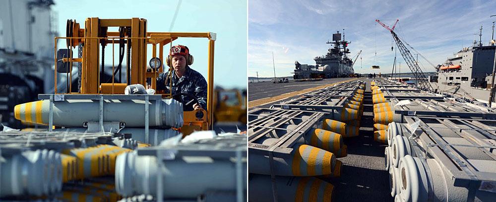
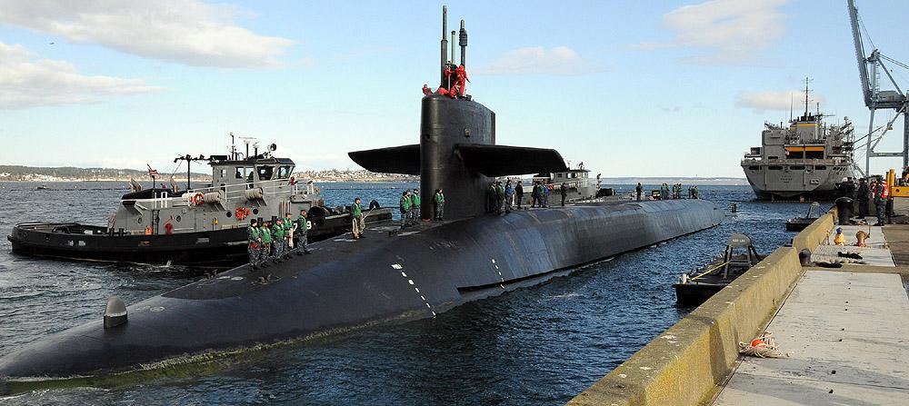
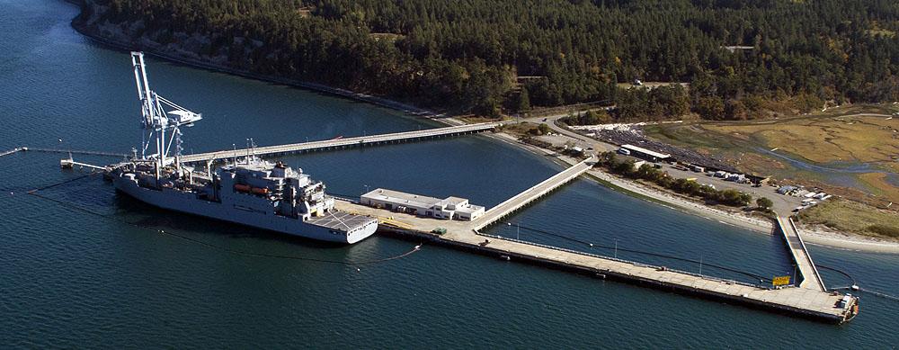
Ships at the Ammunition Pier are serviced by tugs from SUBASE Bangor for docking and undocking evolutions. The type of cargo that is loaded/offloaded is primarily ammunition (e.g., bombs, bullets and missiles).
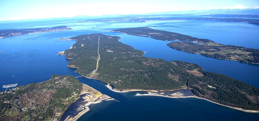
Indian Island is located west of Marrowstone Island between the waters of Port Townsend and Kilisut Harbor. Indian Island is approximately 4.2 nmi long and oriented on a north-south axis between Marrowstone Island and the mainland of the Quimper Peninsula. The Naval Ammunition Depot (NAD) is located on the northwest side of Indian Island.
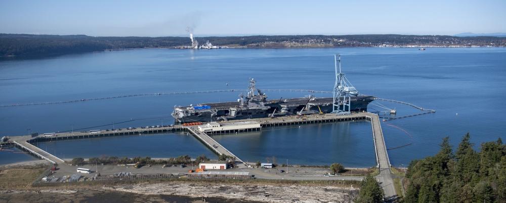
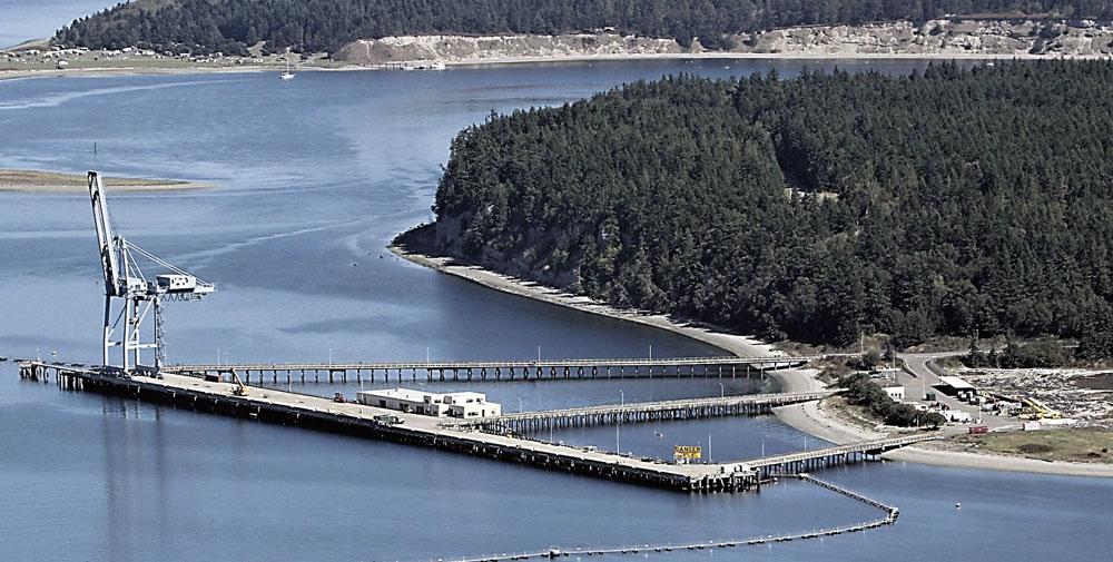
The Ammunition Pier is located on the extreme northwest part of the island at approximately The Ammunition Pier is the primary maritime facility of NAD Indian Island. It is large enough to accommodate a Nimitz class aircraft carrier (1,040 feet long/91,487 to 96,358 tons). The pier is 1,500 feet (457 m) long, not counting tug berths on mooring floats on the south end of the pier. According to harbor pilots at Bremerton, the wooden pilings used in the construction of the pier would not support an aircraft carrier in an on-setting wind, so steel pilings 600 feet apart were installed.
Because of the distance between the steel pilings, camels are now needed by moored ships to accommodate the pilings. A second, older pier is located on the west side of the island south of the ammunition pier, but a 200 feet section was lost in a severe wind storm. It has not been rebuilt and is now condemned. Alongside depths at the Ammunition Pier are 50 feet (15.2 m) or more. The depths increase rapidly away from the pier.
Because of its protected location on Port Townsend, wave motion is not a problem at the Ammunition Wharf. Waves in Admiralty Inlet just outside of Port Townsend can be a problem for inbound and outbound vessels during periods of strong northwesterly winds. Currents are not a significant problem at the Ammunition Wharf.
SUBASE Bangor Harbor Pilots, who service ships at the wharf, state that ebb tides cause strong currents in Admiralty Inlet. Because of the relatively narrow entrance channel, ships destined for the Ammunition Wharf must keep at least 10 kt steerage way until well west of a line between Point Wilson and Marrowstone Point. A strong north-setting current passes west of Indian Island through Port Townsend Canal (between Indian Island and the mainland of the Quimper Peninsula) during an ebb tide, but it is largely diffused by the waters of Port Townsend before it reaches the Ammunition Wharf.
Naval Magazine Indian Island is the only deep water ordnance facility on the West Coast with no access restrictions, such as shallow bridges or water. The island has a 1,650-foot-long pier with 55 feet of draft available at the average low-tide height of water, making it so the Navy can load munitions onto any vessel in the fleet docked at the island's pier.
Naval Magazine Indian Island
https://www.cnic.navy.mil/regions/cnrnw/installations/naval_magazine_indian_island/about.html
During WWII, Indian Island’s personnel worked around the clock to load Navy ships with munitions, assemble mines and manufacture the giant anti-submarine nets that protected Puget Sound waterways from penetration by enemy vessels. At the height of the war, more than 350 military personnel and 200 civilians worked on the island to load vessels seven days a week, sometimes loading two ships a day.
By 1943, the U.S. Navy was looking for a site to build a new Puget Sound ammunition depot. Captain J. W. Rankin, commander for NAD Puget Sound, said it should be near existing rail lines and highways, and have a deep water dock and enough standard-gauge track storage to handle the sorting of railroad cars.
When work levels dropped off after the end of the Korean War, the island was placed in a reduced operating status in 1959. After construction of the Trident Submarine Base at Bangor (Nukes,) the Navy's conventional munitions storage and handling facilities mission shifted back to Indian Island with completion of a new Ammunition Wharf in 1978.
It has more than 100 magazines that store conventional weapons, ranging from small arms ammunition to aircraft ordnance.
Naval Base Kitsap-Bangor
https://www.historylink.org/File/20540
Big Plans for Bangor
Bangor, a small Kitsap County community 16 miles northwest of Bremerton on the east shore of Hood Canal, was chosen for several reasons. Hood Canal offered a direct route to the Pacific Ocean, via the Strait of Juan de Fuca, and it was deep, with no obstructions and only light commercial and recreational traffic. The site was relatively undeveloped, which figured to make land acquisition easier than in more settled areas, and it was big enough to allow for expansion if needed.
Getting it ready for service would require construction of a wharf along the shoreline. It also would require building a rail line connecting it to the closest commercial line, Northern Pacific Railway's tracks some 45 miles away at Shelton in Mason County.

Naval Base Kitsap-Bangor on Hood Canal was a vital ammunition depot from late in World War II to the end of the Vietnam War, and the segregation area was one of its key components. The Bangor depot was built in 1944 and 1945 northwest of Bremerton in Kitsap County. A railroad line was carved through challenging terrain to connect the depot with the closest existing tracks, at Shelton in Mason County, about 45 miles south.
After World War II, transshipment of ammunition rose and fell depending on U.S. military missions. It peaked again during the Vietnam War, when Bangor was the closest U.S. ammunition depot to Southeast Asia. Later the depot became a submarine base and the segregation area was abandoned with 45 railroad boxcars still on its tracks.
While continuing to be a major ammunition depot, Bangor in 1962 was linked for the first time with nuclear weapons. It was selected to assemble and store Polaris missiles. About $44 million was spent on the assembly plant, which was expected to employ several hundred workers and was commissioned in 1964 as the Polaris Missile Facility, Pacific. The commissioning ceremony was attended by Secretary of the Navy Paul H. Nitze (1907-2004) and Vice Admiral Hyman Rickover (1900-1986), an early proponent of nuclear-powered ships and submarines.
Protestors stood outside the main gate and three tried to block traffic, examples of peace demonstrations that grew as Bangor got more involved with nuclear weapons.