Search This Blog

Showing posts with label Bombs. Show all posts

Ammunition Ships and Ammunition Depots On Oahu - Early Navy Ammunition Depot History On Oahu

 Histories Compiled by Ewa Historian John Bond


Ammunition Ships and Ammunition Depots On Oahu


In 1929, the Navy purchased 8,184 acres of the McCandless estate, then a cattle ranch


The first naval ammunition depot in the territory consisted of seven above-ground magazines located on Kuahua Island, Pearl Harbor, in the vicinity of the community and industrial areas of the Naval Shipyard, Pearl Harbor. Kuahua was used from 1916 until April of 1934, when it was decommissioned because of its un-safe Location and limited area avail- able for expansion.


In 1929, the Navy purchased 8,184 acres of the McCandless estate (then being used as a cattle ranch), the area now constituting the Headquarters. About the same time 763 acres were also set aside from the Pearl Harbor Naval Reservation for use by the Depot. Construction on these two locations was begun in 1931 and, on May 1, 1934 they were commissioned as the U,S. Naval Ammunition Depot, Oahu, Hawaii. An additional 325 acres of land adjacent to West Loch Branch was transferred from the Naval Supply Center, Pearl Harbor to the Depot in 1953, thereby in- creasing the land area to 1,088 acres. The latter now contains a greatly improved naval mine facility. The land now occupied by the Waikele Branch was acquired from the U. S. Army in 1942 after construction on the tunnels had begun. It became the second branch of the Depot and covers 520 acres.


Lualualei.--This depot was originally established by the Navy on February 5, 1931. The 7910-acre site had at one time been a forest preserve, and was transferred to the Navy by the Territory of Hawaii. No additional real property was required for expansion.


Magazine construction under the PNAB contract included fifty-three 25-by-80-foot, eleven 50-by-100-foot, and eight 20-by-25-foot concrete structures buried in the hillside, and 24 frame buildings for storage of projectiles and inert material. Other construction included housing for 600 station personnel, shops, administration buildings, roads, walks, and 15 miles of railroad track.


The 125th Construction Battalion arrived at Lualualei in April 1944 to design and construct additional facilities. Among these were 28 miles of asphalt-paved roads, 10 miles of railroad, sorting sheds, shops, utilities, and housing. this work was completed in 10 months and the 125th left in May 1945. The 52nd Battalion arrived in October 1944 and built 18 miles of roadways, additional railroad facilities, and housing. CBMU 581 arrived in March 1944 and took over all maintenance and minor construction.


West Loch.--For the expansion of the West Loch ammunition depot, 358 additional acres were purchased, which enlarged the tract to 537 acres.


New construction included twelve 25-by-50-foot, high-explosive magazines, fifteen 50-by-86-foot, assembled-mine magazines, five 10-by-14-foot and three 20-by-25-foot magazines for fuses and detonators, and 11 magazines for dispersed torpedo storage. In addition, 12 other buildings were constructed to store pyrotechnics, inert material, mine anchors, fixed ammunition, and projectiles. Work on the waterfront included extension of an old wharf and the construction of a new 1000-foot wharf. Also constructed were 9 miles of railroad and personnel structures for 600.


Additional railroad facilities, test buildings, recreational facilities, patrol roads, and sorting sheds were built by the 43rd Seabees. Station maintenance and minor construction were accomplished by CBMU 581.


Waikele Gulch.--The pressing problem presented by the vast amount of explosives stored in the open among the hills and valleys of southern Oahu crystallized in mid-June 1942, when the Commander-in-Chief of the Pacific Fleet directed that "underground ammunition storage of major proportions" be constructed in a location that would "both be readily defended by, and accessible to, Pearl Harbor."


A 350-acre site was selected where steep-banked ravines made possible tunnel construction in such a manner that no two entrances faced each other, and a railroad spur could be built to service the installation.


Most of the tunnel roofs were concreted, and the floors were built of reinforced concrete. Concrete sidewalls were carried to a 7-foot height, mainly as

gravity retaining walls. The loading platforms were of concrete.


Facilities included 120 tunnels, each 240 feet long, which required 9 miles of railroad, 10 miles of paved road, 9 miles of patrol road, four bridges, and housing and messing facilities for operating personnel. Work on this project, begun in September 1942, was completed in December 1943.


In April 1944 the 125th Battalion arrived, followed in May by the 95th, to carry out additional construction, upon completion of which the depot was turned over to CBMU 581.


AE Ammunition Ships

https://www.globalsecurity.org/military/systems/ship/ae.htm

Explosives are primarily in divisions 1.1 and 1.5. Division 1.1 denotes a "mass explosion hazard". This means that all, or nearly all, of the explosive compound within a given load or device will detonate instantaneously, producing a blast overpressure of supersonic velocity. Detonation velocity of division 1.1 material is approximately 10k to 30k feet per second.

The term "net explosive weight (NEW)" refers to the weight of ONLY the explosive material in a given load, device, or article. For example, a military 1000-pound bomb might weigh 1000 pounds, but it contains only 385 pounds of explosive material. The bomb casing and other non-explosive parts of the device, such as guidance components, etc, account for the remainder of the weight. Hence, the total NEW of 5 such "1000 pound" bombs would be 1925 pounds.

Military Ocean Terminal Sunny Point (MOTSU) in Wilmington, NC

The Army Net Explosive Weight (N.E.W.) aboard these ships is in excess of 13 million pounds. The location and situation at Diego Garcia affords the opportunity to exceed normal port anchorage restrictions. AMC sponsored a viable solution to reducing this excess N.E.W. by cross-leveling amongst three vice two ammo container ships. In order to position these ships at the desired locations with the ARFs, the N.E.W. must be reduced per ship to < 8.0 million pounds N.E.W..

The Army has a history of not using all prepositioned afloat ammo during contingencies and this data can be used to reduce the N.E.W. above and beyond the introduction of a third ship for cross-leveling. The reduction in N.E.W. below 8.0 million pounds is critical for both anchorage and portside download vice in-stream discharge.

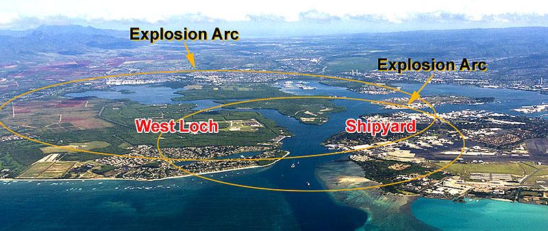
The effects of N.E.W. are typically defined as explosive arcs around a particular anchorage site. In addition to avoiding civilian infrastructure within that arc, another major impact is proximity to commercial shipping lanes. Major global commercial seaports that can offload a deep draft ammo container ship are surrounded by ingress and egress shipping lanes which significantly reduces potential portside offloads.
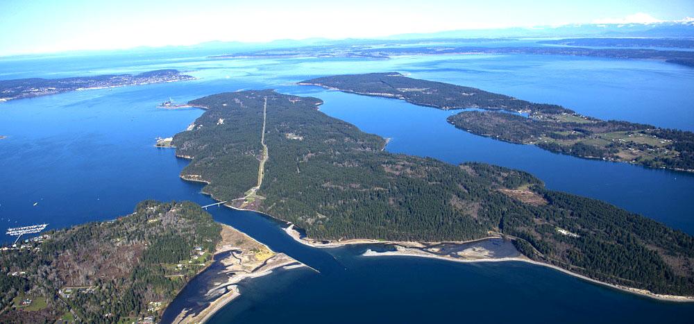
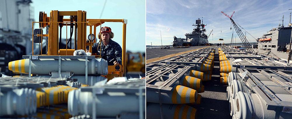
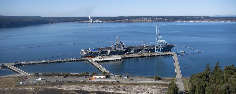
Indian Island – The West Coast's major Navy ammunition site

 Compiled by Ewa Historian John Bond

Indian Island – The West Coast's major Navy ammunition site

https://www.globalsecurity.org/military/facility/indian-island.htm

Ammunition Depot Indian Island, Port Hadlock, Washington

https://www.kitsapsun.com/story/news/2017/11/26/little-known-island-logistics-backbone-pacific-northwest-navy-fleet/886272001/


A new command officially joined the four major US Navy installations of Navy Region Northwest during a brief ceremony 27 April 2000. The former Naval Weapons Station Seal Beach, Detachment Port Hadlock, officially became Naval Magazine Indian Island. The 2,716-acre facility now reports directly to the region commander rather than a series of others in the Southwest. The mission of providing ordnance-related support including receipt, storage, issuance, and inspection did not change, nor did the staffing of approximately 12 active duty members and 124 civil service and contract employees. Effective 01 October 1999, Naval Magazine [NAVMAG] Indian Island (formally known as Port Hadlock Weapons Detachment) had its support moved from the southwest region (Seal Beach) to the northwest region (Subase Bangor).


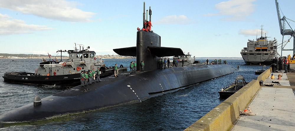
Ships at the Ammunition Pier are serviced by tugs from SUBASE Bangor for docking and undocking evolutions. The type of cargo that is loaded/offloaded is primarily ammunition (e.g., bombs, bullets and missiles). 


Indian Island is located west of Marrowstone Island between the waters of Port Townsend and Kilisut Harbor. Indian Island is approximately 4.2 nmi long and oriented on a north-south axis between Marrowstone Island and the mainland of the Quimper Peninsula. The Naval Ammunition Depot (NAD) is located on the northwest side of Indian Island.


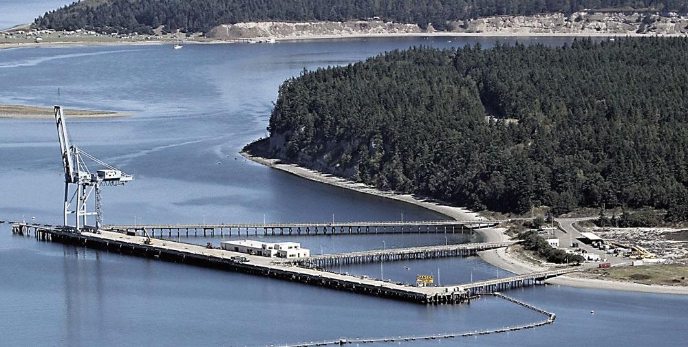
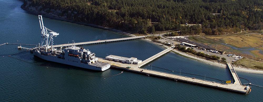
The Ammunition Pier is located on the extreme northwest part of the island at approximately The Ammunition Pier is the primary maritime facility of NAD Indian Island. It is large enough to accommodate a Nimitz class aircraft carrier (1,040 feet long/91,487 to 96,358 tons). The pier is 1,500 feet (457 m) long, not counting tug berths on mooring floats on the south end of the pier. According to harbor pilots at Bremerton, the wooden pilings used in the construction of the pier would not support an aircraft carrier in an on-setting wind, so steel pilings 600 feet apart were installed.


Because of the distance between the steel pilings, camels are now needed by moored ships to accommodate the pilings. A second, older pier is located on the west side of the island south of the ammunition pier, but a 200 feet section was lost in a severe wind storm. It has not been rebuilt and is now condemned. Alongside depths at the Ammunition Pier are 50 feet (15.2 m) or more. The depths increase rapidly away from the pier.


Because of its protected location on Port Townsend, wave motion is not a problem at the Ammunition Wharf. Waves in Admiralty Inlet just outside of Port Townsend can be a problem for inbound and outbound vessels during periods of strong northwesterly winds. Currents are not a significant problem at the Ammunition Wharf. 


SUBASE Bangor Harbor Pilots, who service ships at the wharf, state that ebb tides cause strong currents in Admiralty Inlet. Because of the relatively narrow entrance channel, ships destined for the Ammunition Wharf must keep at least 10 kt steerage way until well west of a line between Point Wilson and Marrowstone Point. A strong north-setting current passes west of Indian Island through Port Townsend Canal (between Indian Island and the mainland of the Quimper Peninsula) during an ebb tide, but it is largely diffused by the waters of Port Townsend before it reaches the Ammunition Wharf.


Naval Magazine Indian Island is the only deep water ordnance facility on the West Coast with no access restrictions, such as shallow bridges or water. The island has a 1,650-foot-long pier with 55 feet of draft available at the average low-tide height of water, making it so the Navy can load munitions onto any vessel in the fleet docked at the island's pier.


Naval Magazine Indian Island
 
https://www.cnic.navy.mil/regions/cnrnw/installations/naval_magazine_indian_island/about.html


During WWII, Indian Island’s personnel worked around the clock to load Navy ships with munitions, assemble mines and manufacture the giant anti-submarine nets that protected Puget Sound waterways from penetration by enemy vessels. At the height of the war, more than 350 military personnel and 200 civilians worked on the island to load vessels seven days a week, sometimes loading two ships a day.


By 1943, the U.S. Navy was looking for a site to build a new Puget Sound ammunition depot. Captain J. W. Rankin, commander for NAD Puget Sound, said it should be near existing rail lines and highways, and have a deep water dock and enough standard-gauge track storage to handle the sorting of railroad cars.


When work levels dropped off after the end of the Korean War, the island was placed in a reduced operating status in 1959. After construction of the Trident Submarine Base at Bangor (Nukes,) the Navy's conventional munitions storage and handling facilities mission shifted back to Indian Island with completion of a new Ammunition Wharf in 1978.


It has more than 100 magazines that store conventional weapons, ranging from small arms ammunition to aircraft ordnance.  


Naval Base Kitsap-Bangor

https://www.historylink.org/File/20540

Big Plans for Bangor


Bangor, a small Kitsap County community 16 miles northwest of Bremerton on the east shore of Hood Canal, was chosen for several reasons. Hood Canal offered a direct route to the Pacific Ocean, via the Strait of Juan de Fuca, and it was deep, with no obstructions and only light commercial and recreational traffic. The site was relatively undeveloped, which figured to make land acquisition easier than in more settled areas, and it was big enough to allow for expansion if needed. 

Getting it ready for service would require construction of a wharf along the shoreline. It also would require building a rail line connecting it to the closest commercial line, Northern Pacific Railway's tracks some 45 miles away at Shelton in Mason County.


Naval Base Kitsap-Bangor on Hood Canal was a vital ammunition depot from late in World War II to the end of the Vietnam War, and the segregation area was one of its key components. The Bangor depot was built in 1944 and 1945 northwest of Bremerton in Kitsap County. A railroad line was carved through challenging terrain to connect the depot with the closest existing tracks, at Shelton in Mason County, about 45 miles south.


After World War II, transshipment of ammunition rose and fell depending on U.S. military missions. It peaked again during the Vietnam War, when Bangor was the closest U.S. ammunition depot to Southeast Asia. Later the depot became a submarine base and the segregation area was abandoned with 45 railroad boxcars still on its tracks.


While continuing to be a major ammunition depot, Bangor in 1962 was linked for the first time with nuclear weapons. It was selected to assemble and store Polaris missiles. About $44 million was spent on the assembly plant, which was expected to employ several hundred workers and was commissioned in 1964 as the Polaris Missile Facility, Pacific. The commissioning ceremony was attended by Secretary of the Navy Paul H. Nitze (1907-2004) and Vice Admiral Hyman Rickover (1900-1986), an early proponent of nuclear-powered ships and submarines. 


Protestors stood outside the main gate and three tried to block traffic, examples of peace demonstrations that grew as Bangor got more involved with nuclear weapons.


Kipapa Ammunition Storage Site (KASS) History

 Compiled by Ewa Historian John Bond 

Kipapa Ammunition Storage Site (KASS) History 

Army concrete ammunition tunnels on Oahu have been estimated to total at least 16 miles in length, from Koko Head to Moanalua.

The Kīpapa Ammunition Storage Sites (KASS) are located in the Kīpapa Gulch to the southeast of Wheeler Army Airfield on Oahu's central plateau and consists of 374.4 acres. During World War II, 1944, the Army Corps of Engineers built one of the most extensive sets of underground storage sites in the Hawaiian Islands. The sites contain 79 tunnels or magazines of standard size and shape excavated into the canyon walls of Kīpapa Gulch and fitted with large steel doors.

The Army Kipapa Ammunition Storage Sites (KASS), KASS are located within the Kipapa Stream Valley of Central Oahu, approximately 12 miles northwest of the city of Honolulu. It consists of two separate land areas: Lower Kipapa, which is located towards the southern portion of the stream valley, south of Mililani town and a half-mile west of the town of Waipio, and Upper Kipapa, which is located towards the northern portion of the stream valley adjacent to the southeastern side of Mililani town. The two areas, totaling approximately 400 acres, are separated by a distance of about one mile.

The Upper Kipapa facility contains 53 tunnels in Upper Kipapa, while the Lower Kipapa facility contains 26 tunnels dug into the rock formation of both sides of Kipapa gulch. In total, KASS has 70 buildings and structures over 50 years old in the RPLANS real property database; 68 of these are ammunition storage or air raid/fallout shelter with active historic status (listed, eligible, or contributing to an eligible historic district). There are an additional 2 air raid/fallout shelters not yet evaluated.

The Kipapa storage tunnel sites were constructed during World War II for the purpose of storing incendiaries and high explosives. The tunnels were subsequently used to store insecticides and chemical agents, primarily mustard gas, but also phosgene and lewisite. All of the tunnels have reportedly been sealed, except for one magazine in the Lower Kīpapa group utilized by the National Oceanic and Atmospheric Administration (NOAA) as a tsunami and earthquake detection station, Pacific Cooperative Studies Unit University of Hawaii, 2010.

At the onset of World War II, the Army was importing ammunition in huge quantities, requiring construction of ammunition storage facilities. Small facilities were built above ground, but the bulk of the ammunition was stored in massive underground storage facilities. The first to be developed was in Waikakalaua Gulch just south of Wheeler Field, as well as at Kipapa Gulch.

“Tunnels driven into the almost vertical walls of the two gorges would have entrances invisible from the air. To keep out bomb fragments, passageways to the storage chambers would be dog-legged or provided with baffles.”

The tunnel numbers are identified in historical records, but there are identified discrepancies with the current tunnel numbers. Possible reasons for the discrepancies are that the numbering changed or the tunnels referred to in the reports are actually located at another installation (i.e. Waikakalua or Waikele). Readily available documentation is missing these key details.

The historic reports documented many instances of leaking bombs. The extent of leaking is not usually described and there is little mention of soil; however, some photos clearly show leaking agent on the ground in some tunnels. It is not possible to tell which tunnels these are from the information garnered to this point. The records were originally secret or confidential, but have since been declassified. The date of declassification is not known at this time.

The tunnels in Lower Kipapa were put out of service and all munitions removed in the early-1960s. The last of the chemical munitions and gas identification kits were removed from the site in the early-1970s. The tunnels in Upper Kipapa were also put out of service at that time. After removal of the chemicals and ammunition, a few of the tunnels were used by the Army for other purposes which included prisoner of war (POW) training.

Kipapa Ammunition Storage Site, located in Kipapa Gulch, was comprised of three sections. The lower unit is accessed from the south side of the Kamehameha Highway Bridge and extends south to the Kipapa Navy Ammunition Storage Area. The other two units are in the gulch to the east of Mililani Town.

Other tunnel complexes were built, including Schofield Barracks, Wheeler Field, Fort Shafter and Fort Ruger. The tunnels at Wheeler Field and Fort Ruger were for ammunition storage. The tunnels at Fort Shafter included a bombproof radio station, an underground cold storage facility, an anti-aircraft command radio transmitter tunnel, and the Air Defense Command Post. (army-mil)

The property is excess to the needs of the Army and US Army Garrison (USAG)-HI plans to transfer the property to a private land owner following the performance of all required site investigations and potential remedial actions. Due to the former use of the property, it is critical to ensure that transfer does not present a risk.

An RI/FS was funded in FY14 to determine the nature and extent of contamination at the site. The RI fieldwork is currently underway. The RI/FS will determine the need for future phases of work.


The extensive Waikele Tunnel Complex was given away by the Navy in the Ford Island land deal orchestrated by Sen. Inouye and Rep. Abercrombie in 2003

This system of tunnels was the location of the primary storage for ordinance for B-17s and other bombers stationed just above at the Kipapa Army Airfield. The site was also used to store anti-tank and rifle fragmentation grenades. (army-mil)

Kipapa Ammunition Storage Site, located in Kipapa Gulch, was comprised of three sections. The lower unit is accessed from the south side of the Kamehameha Highway Bridge and extends south to the Kipapa Navy Ammunition Storage Area. The other two units are in the gulch to the east of Mililani Town.


By WW-II's end, the Army had built 37 miles of runways, 32 miles of taxiways, 2.7 million square yards of aircraft parking, and 470 aircraft bunkers.

Fort Ruger – Fort Shafter Tunnels

Other tunnel complexes were built, including Schofield Barracks, Wheeler Field, Fort Shafter and Fort Ruger. The tunnels at Wheeler Field and Fort Ruger were for ammunition storage. The tunnels at Fort Shafter included a bombproof radio station, an underground cold storage facility, an anti-aircraft command radio transmitter tunnel, and the Air Defense Command Post. (army-mil)

In connection with Richardson Hall there are three underground, bombproof tunnels in its vicinity. Tunnel 103 is presently a command center, while the current uses of tunnels 113 and 114 are unknown. National Register of Historic Places Inventory Fort Shafter.

Kunia Tunnels

Army construction during this period also included “The Hole” (now the Kunia Field Station,) a facility originally intended for airplane assembly (with a runway connection to Wheeler Field to the east.)

“The entrance appeared to lead only to a small dugout in a rolling hill, but at the end of a quarter-mile tunnel two elevators – one big enough for 20 passengers and the other able to carry four ½-ton trucks – gave access to a three-floor structure, self-sufficient even to a cafeteria that could serve 6,000 meals a day.”

“’The Hole’ was intended for plane assembly, but since it was not needed for such use, it proved ideal for the reproduction of maps and charts. Its huge air conditioning and ventilating systems provided easy control of temperature and humidity, and its fluorescent lighting furnished a flood of shadowless illumination.” (Allen; army-mil)

Kunia Regional SIGINT Operations Center

https://en.wikipedia.org/wiki/Kunia_Regional_SIGINT_Operations_Center


http://totakeresponsibility.blogspot.com/2013/10/the-hole.html

In a first, NSA allows news cameras into Kunia facility. And vets aren’t happy

https://www.hawaiinewsnow.com/2019/05/21/kunia-veterans-say-theyre-shocked-still-ignored-after-top-secret-nsa-tour/

Aliamanu Crater Tunnels

http://www.rcarchive.com/hhg/alia.html


In October 1941, work was started to convert the storage facility in the rim of Aliamanu Crater into a joint Army-Navy command post; although not completed at the time of the Japanese attack on Pearl Harbor, the post was shortly after put into service by the island command.

To alleviate continued housing shortages in the early-1970s, the Army, Navy, and Marines developed a joint project at Āliamanu Military Reservation, once a World War II era Navy-Army command post and important ammunition storage facility.

The ammunition was moved to the Lualualei storage depot and the crater was transformed into a 2,600-unit housing development.

You can get an idea how HUGE these Waikakalaua Ammo Storage tunnels are by looking about halfway into this hike video


https://www.youtube.com/watch?reload=9&v=RClHh4gO6Q0

Apparently some ordinance cleanup was or will be done by 2015-20??

https://aec.army.mil/application/files/4715/0007/9167/HI-WAIK.pdf

http://imagesofoldhawaii.com/ammo-tunnels/

World War II fortifications still present on O'ahu


"I suspect that if you were to use the term 'Gibraltar of the Pacific,' you could get away with that without much argument," historian William Gaines said. "At the end of World War II, O'ahu was probably the most heavily armored island in the world."

There are far more batteries and bunkers out there than meet the eye. Many who have had access to them discover inside them more than an echo and moldy interior.

"We're surprised every day. We find more and more," said John Bennett, a retired city prosecutor's investigator and member of the Coast Defense Study Group.

The military controlled one-third of O'ahu during the war years, and one Army official said there are probably 300 tunnels.

Sandii Kamaunu, owner of Military HQ on Sand Island Access Road, several years ago bought up a Civil Defense field hospital stored and long forgotten since the early to mid-1950s in a World War II gun battery in Kailua. She was flabbergasted by what she found.

The cache included hundreds of sealed crates. There were 200 cots and 200 wool blankets, splints, blood transfusion kits, porcelain bed pans and urinals, and vials of dried-up potassium penicillin crystalline for shots that Kamaunu says were given with "horse needles that hurt like hell." Some of the items bore 1940s dates.

All were like new, in the box, directions included.

Wayne Jones, the acting director of the O'ahu Civil Defense Agency, remembers inspecting the supplies.

"There was an old dentist's chair up there if I remember correctly, an old operating table — all stainless steel — but of no use to us," Jones said.

For decades, Ron Deisseroth and his mushroom business co-existed with the field hospital in twin 155-foot-deep bunkers, a spot that suited both. Sheltered beneath at least 200 feet of earth at the deepest point, Battery 405 — with kitchen, infirmary and bunks — originally supported two MK VI 8-inch Navy guns. Five similar batteries were built around the island. A facade meant to look like a two-story home — intended to throw off would-be invaders — once camouflaged the tunnel's entrance.

Deisseroth, who grew mushrooms from 1950 to about 1992, remembers schoolchildren trooping up the hill for a disaster preparedness drill.

"I guess they wanted them to know where to go in case of an attack," said the O'ahu man, who leased the property from Kane'ohe Ranch.

There are also many large tunnel systems on Oahu for 

Artillery Gun Batteries to support 8 and 14 inch guns


Lualualei Naval Ammunition Depot History

 Compiled by Ewa Historian John Bond from public documents

Lualualei Naval Ammunition Depot History

Established By The Navy On February 5, 1931 In A Forest Preserve

The Lualualei Naval Ammunition Depot was originally established by the Navy on February 5, 1931. The 7910-acre site had at one time been a forest preserve, and was transferred to the Navy by the Territory of Hawaii. No additional real property was required for expansion.

After the start of WW-II, magazine construction under the Contractors Pacific Naval Air Base (CPNAB) contract included fifty-three 25-by-80-foot, eleven 50-by-100-foot, and eight 20-by-25-foot concrete structures buried in the hillside, and 24 frame buildings for storage of projectiles and inert material. Other construction included housing for 600 station personnel, shops, administration buildings, roads, walks, and 15 miles of railroad track that connected to the Oahu Railway line that ran to Pearl Harbor and on into Honolulu.

Navy SeaBees (CB Construction Battalion) arrived at Lualualei in April 1944 to design and construct additional facilities including 28 miles of asphalt-paved roads, 10 additional miles of railroad, sorting sheds, shops, utilities, and housing. Another Navy CB Battalion arrived in October 1944 and built an additional 18 miles of roadways, additional railroad facilities, and housing. A Navy CBMU (Construction battalion Maintenance Unit) arrived in March 1944 and took over all maintenance and minor construction responsibilities for Lualualei NAD.


This is Lualualei in leeward Oahu. This naval magazine has gradually been shut down and the last tenant is the US Army which has been keeping its munitions there. Now the army plans to remove all remaining munitions over to a new Army Munitions Complex directly next to the communities of West Loch Estates, Ewa by Gentry, Ewa Villages and Ewa Beach.

The Army is also building many new Type D missile magazines for new missiles and long range artillery shells. There are major new weapons being developed largely in anticipation of the coming war with China. China’s military is making increasingly aggressive military moves in the Pacific with Guam and Hawaii in their bomb sites. The US Military is countering this with a rapid buildup of advanced new missiles to hit ship and island targets in the Pacific.

Cost of Compliance on Graduate School of Business & Public Policy Thesis, December 2017, Naval Postgraduate School, Munitions Consolidation from Lualualei to West Loch

https://calhoun.nps.edu/handle/10945/58904

In 1967, the Naval Ordnance Safety and Security Activity (NOSSA) came out with more restrictive safety standards mandating that the distance between each magazine must be greater than what is currently installed at West Loch (NAVSEA, 2017). Due to the lack of permissible net explosive weight (NEW) allowed per the NOSSA standards, Navy Munitions Command has been using several magazines in Lualualei to store smaller-sized ordnance.

The 1995 Hawaii Military Land Use Master Plan (HMLUMP) recognized the importance of Hawaii’s strategic location as a “bridge to Asia” and, as a result, recommended the release of the Lualualei Annex due to its aging magazines and its consolidation with West Loch pending construction of new facilities.

The 2002 Commander, Navy Region Hawaii (CNRH) Ordnance Facilities Plan, proposed a significant investment in new ordnance infrastructure for new magazines near West Loch. Additionally, in 2003, PACFLT identified that only four out of 299 magazines in Hawaii are capable of storing modern missiles for naval destroyers and submarines.

The two courses of action according to the Navy’s analysis are as follows: Option 1. Navy builds new magazines, Army builds new magazines, and both consolidate in West Loch in accordance with NOSSA standards. Option 2. Current magazines at Lualualei are upgraded to NOSSA standards and current operations remain the same for Navy and Army. Option 1 may sound reasonable but does not take in account the required ESQD – safety zone, according to information made available to the public in 2018 by the Army MOTSU presentations. The Army munitions complex will be just .5 (1/2 mile) from the nearby communities.

Rising tensions in the Pacific with China, North Korea, and Russia could lead to combat operations in the Pacific. The West Loch Hawaii’s will need to store additional prepositioned munitions, hold ordnance for ships undergoing repairs, and resupply more deploying ships to the Pacific. The West Loch channel has already been expanded to handle large newer Navy ammunition ships, such as handled by the Army MOTSU site in North Carolina which has a 3.5 mile ESQD safety arc, compared to West Loch which has a very much smaller ESQD and is located right next to many suburban homes in Ewa West Oahu.

See Figure 3 for the layout of West Loch and shows the explosive safety boundaries associated with ammunition operations. Unlike Lualualei, West Loch is closer to residential areas. Ordnance operations in both Lualualei and West Loch are contracted out and are renewed annually by the Navy.

Global Security: Naval Magazine, Lualualei May 2011

https://www.globalsecurity.org/military/facility/lualualei.htm

The Naval Magazine is located in Lualualei Valley on the leeward side of Oahu, with headquarters a few miles inland from the towns of Waianae and Nanakuli. The shipping and receiving center is located at West Loch. The Naval Magazine is a terminus for the kolekole Pass road which traverses the beautiful Waianae Mountains. The drive extends from the Waianae coast to Schofield Barracks and offers panoramic views. The road is closed to the public, but open to military personnel and their dependents on most days until sunset.

In January 2000 the designation Naval Magazine, Lualualei, Hawaii, was changed to Naval Magazine Pearl Harbor. The name change was a result of the command's recent headquarters move from the Lualualei Branch to Pearl Harbor's West Loch. Fifty W-80-0 munitions for Tomahawk SLCM's and 40 nuclear aerial bombs are stored in the Lualualei Naval Magazine (NAVMAG) at West Loch on Oahu, Hawaii according to Global Security.org.

In January 2000 Naval Magazine Lualualei held its official ribbon-cutting ceremony for the grand opening of the new headquarters building, located in the West Loch Branch, Ewa Beach. The Commanding Officer, Capt. Shawn Morrissey, kicked off the ceremony with an introductory speech. Following his speech, Lt. Leila Havadtoy provided a blessing for the new headquarters building. After the ribbon was officially cut, all attendees gathered together for a potluck barn-warming celebration, which was held right next to the waterfront and the headquarters. 

Lualualei is located on land that consists of a thin layer of alluvial and coastal sediments and reef deposits overlying consolidated limestone. Civilian land use surrounding this facility is largely rural and the site is surrounded by agricultural and small areas of Urban and Conservation Land Use districts. Naval Magazine Lualualei, which occupies 8,105 acres of the valley. The nearest urban area is the town of Maili, which lies approximately 1 mile west of the station. The towns of Waianae and Nanakuli are also located nearby. Kolekole Pass is a narrow mountain road across the Waianae Mountain Ranges that provides vehicular access to Schofield Barracks. Lualualei is approximately 27 miles from downtown Honolulu. 

http://archives.starbulletin.com/98/10/05/news/story1.html

The Navy owns more than 9,000 acres in the Waianae Valley. Its radio towers are a familiar sight, but more goes on beneath the earth

The Navy has used Lualualei as an ammunition depot (initially Naval Ammunition Depot Oʻahu, now Naval Magazine Pearl Harbor) and a communications facility (Lualualei Naval Radio Transmitting Facility) since 1934.

Kolekole Pass forms a low crossing point through the Waiʻanae Mountains.  A prehistoric trail crossed Kolekole pass linking Waiʻanae Uka with Waiʻanae Kai.

Kolekole Pass Road is located on the federal lands connecting these military facilities on Waiʻanae coast of Oʻahu to Schofield Barracks Army Installation in Central Oahu.  The Army's 3rd Engineers corps constructed vehicular passage in 1937.

The Magazine facility, a terminus for the Kolekole Pass road, contains 255 aboveground storage structures capable of housing 78,000 tons of ammunition and explosives.  (hawaii.gov)  The shipping and receiving center is located at West Loch, Pearl Harbor.


*********************************************************************

Kolekole Pass open for defense workers     


June 8, 2005

By William Cole  Advertiser Military Writer


As post-9/11 terrorism concerns on Hawai'i military bases have waned, Kolekole Pass — a favorite shortcut through the Wai'anae range for the military — has again been reopened for defense personnel, but not the public.

The twisting route, constructed by the Army's 3rd Engineers in 1937 across a low spot in the mountain range, and frequently mistaken for the Japanese attack route on Dec. 7, 1941, traverses Lualualei Naval Reservation and Schofield Barracks.

For years, some residents have called for the four-mile road to be opened as an alternative to Farrington Highway, the only access to the Wai'anae Coast and frequent site of traffic jams and accidents that sometimes close the roadway.

But because of security concerns, the Navy said it plans to keep Kolekole Pass closed to the public.

"Lualualei is an ammunition depot, and it's used by both Navy and Army," said Navy Region Hawai'i spokeswoman Agnes Tauyan. "It's a Navy installation — I know the Army has different procedures and I can't speak to that — but as such, (Lualualei) is not open to the public."

According to defense contractor BAE Systems, Lualualei occupies 8,195 acres and has 255 above-ground magazines with a storage capacity of 78,000 short tons of ammunition and explosives.

The road's two gates had been closed to the military since the Sept. 11, 2001, terrorist attacks. The Army and Navy recently agreed to open them for military traffic from 5:30 a.m. until 5:30 p.m., seven days a week, Tauyan said.

"It's good news for the people who work on post, for example our (Defense Department) employees," said Capt. Juanita Chang, a Schofield Barracks spokeswoman.

The move also coincides with greater base access at Schofield Barracks with the relatively low terrorism threat level of "Alpha."

The rating is one stop above "Normal," which applies when there is no discernible terrorist activity. "Normal" is followed by Alpha, Bravo, Charlie and Delta.

Although there has been the call to open Kolekole Pass, which has an access from Wai'anae Valley and Lualualei Naval roads, Albert H. Silva, who lives in Kea'au and is vice chairman of the Wai'anae Coast Neighborhood Board, said the Kolekole Pass road was at one time declared unsafe, and there are no retaining catchments for rockslides.

Silva worked at the ammunition depot and in Wahiawa, and he said driving Farrington Highway around to Kunia and then Wahiawa was only a slightly longer trip than driving the Kolekole Pass.

"The time savings for me then was only a few minutes, and when I heard about the hazards, I'd rather not go through there," Silva said. "The gain, to me, was only, say, if it was an emergency."

The Navy periodically makes Kolekole Pass available to the public, as was the case in July 2003 when a police officer and a child were killed and five other people were injured in a head-on collision that closed all four lanes of Farrington Highway.

Officials said military IDs will be checked randomly on the pass, and new signs prohibit stopping on the road, except at a lookout or in case of emergency.


Environmental Impact Statement (EIS) Dry Dock Replacement And Waterfront Production Facility. Major Expansion of West Loch Depot Endangers Pearl Harbor-Hickam

  JOHN M. BOND KANEHILI HUI REPORT AND TESTIMONY Environmental Impact Statement (EIS) Dry Dock Replacement And Waterfront Production Facilit...