How To Determine West Loch Explosive Arc Circle and EQSD (Explosives Safety Quantity Distance)
What is the Explosive Circle at West Loch? People have heard about it for many decades and news articles written about it but the Navy has never produced a map. There is no reason not too because unlike popular belief, it actually doesn’t represent a potential nuclear explosion because if there was one it would likely wipe out a five or ten mile radius at least, so no one wants to see a map showing that.
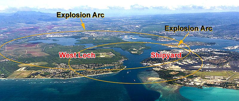
No, the West Loch explosive arc represents a huge conventional munitions explosion event like 1941 USS Arizona or 1944 West Loch disasters* (see these listed in reference section.) So if we don’t have any official map that the Navy will provide we can “reverse engineer” the arc based upon using geometry and history information. Below is a 1942 map showing the West Loch ammunition wharf loading sites.

Using the Photoshop circle selection tool and Google Earth the full circle of the arc can be determined by expanding it until it fits into the visible west side arc next to the Ewa communities, seen below.

The radius of the circle points to Whiskey wharf site W 1-3 – Pearl Harbor munitions transfer epicenter.

Above is an historic map of the West Loch depot from a HABS report for the key historic Building 1.
The historic map shows an ESQD (Explosives Safety Quantity Distance) arrow pointing southwest of 7405 feet (1.4 miles.) This is a primary clue as it is close to the circle visible arc seen in Google Earth. So what determined that it should be that explosives safety distance and using what munitions danger criteria? Fortunately while researching this I found a great on-line munitions hazard tool produced by the United Nations ITAG (International Technical Ammunitions Guideline) which scales to net explosives input.

By putting in the coordinates for West Loch Pearl Harbor the program shows the explosive blast circle. Then add in the quantity of explosives to fit the circle area- and that is 150,000 kg. Hazard Division 1.1 Explosives are basically TNT type munitions. 150,000 kg = 330693.39 pounds of munitions explosives. Note that purple is the Vulnerable Building Distance (VBD seen top right) 2359m (1.46 miles.)

So how to determine the ESQD (Explosives Safety Quantity Distance) for the Army’s planned new Munitions Storage Complex? There are numerous variables in determining an ESQD because it all depends on how much ammunition, what type, etc. So, the only ballpark way of determining it is to use the previous Navy ESQD centered over Building 1 but moving the arc westward to the approximate center of the new Army Munitions Storage Complex and using Hazard Division 1.1 Explosives input.

The result of the westward circle plot shows the purple VBD is 2359m (1.46 miles) and seriously overlaps into the Ewa community, reaching Fort Weaver Rd. Keep in mind that military convoys carrying high explosives will be on local Ewa community roadways. The significance of all of this can be seen in the next set of very relevant information provided by the Army for briefing the local North Carolina Military Ocean Terminal Sunny Point (MOTSU.) This community brief provided very rare explosive blast circle determination factors that can and should be applied to the Army planned Munitions Storage Complex.
MOTSU Provides Important Clues About Planned Army West Loch Munitions Storage Complex
Military Ocean Terminal Sunny Point (MOTSU) is one of the largest military terminals in the world. In 2018 the long secretive and mostly classified facility used a $270,000 Department of Defense grant with $30,000 local matching funds for a Joint Land Use Study (JLUS) designed to improve military and community collaboration. The 209-page study acknowledges MOTSU can improve its communication efforts with the public and outlines ways municipal partners can consider the military’s mission while managing the NC region’s explosive growth. (i.e. like Ewa West Oahu)

https://www.ourstate.com/military-ocean-terminal-sunny-point/
This is where the mighty ships come in to load or unload their cargo of weapons: rockets, missiles, howitzers, grenades, projectiles, pyrotechnics. The Military Ocean Terminal Sunny Point (MOTSU), run by the U.S. Army, is the nation’s largest ocean terminal for military munitions. “Wherever we’re fighting is probably where we’re sending stuff, or they’re sending stuff back to us,” says Steve Kerr, the deputy to the commander at MOTSU. (West Loch serves a similar purpose for Indo-Pacific military operations.)
https://en.wikipedia.org/wiki/Military_Ocean_Terminal_Sunny_Point

A catastrophe served as the genesis for MOTSU. On July 17, 1944, military munitions exploded at Port Chicago near San Francisco. The fireball soared nearly two miles into the sky and port was flattened, every building in the neighboring town was damaged, and the rumble was felt as far away as Nevada. (See section below on 1941 USS Arizona, 1944 West Loch, 1917 Halifax munitions explosions reference.)
The MOTSU Blast Zone Arc and criteria to determine it revealed to the local public for the first time
The so-called “blast zone” arc is confined to land owned outright by the federal government, inside the “buffer zone” on Carolina and Kure Beaches. This arc represents the minimum distance that can be safely maintained between an explosive site and habitable building.
Last year, after initiating the JLUS, the military terminal shared the radius of its previously undisclosed blast safety arcs. https://capefearcog.org/wp-content/uploads/2018/11/November-Policy-Committee_web.pdf
Local news coverage: https://portcitydaily.com/local-news/2019/07/14/what-motsu-wants-u-s-army-presents-53-recommendations-for-local-governments/
Public community meetings revealed that at roughly twice the size of the Inhabited Building Distance (IBD), the K88 quantity-distance arc includes areas with a high probability of glass breakage in the event of a terminal explosion. According to its former commander, Col. Marc Mueller, the K88 has remained unchanged for MOTSU, but the distance was new to the public when the military released it in 2018. There is also criteria for community emergency evacuations for initial response to an incident involving ammunition/explosives. Distance applies to any given facility – docks were used as an example.

Using an example from MOTSU, a 1,000,000 blast zone radius for Vulnerable Building Distance (VBD) would be 4440 meters or 2.76 miles. This means Waipahu, Ewa west of Kualaka’i Parkway (AKA North South Road) Ewa Beach- Ocean Pointe (Haseko) Ewa Gentry – Ewa Villages, and over to Iroquois Point. The Inhabited Building Distance (IBD) is 2220M or 1.4 miles. This is very interesting as it is exactly the same distance as shown in the historic Building 1 map of “Whisky” wharf W 1-2-3, which shows an ESQD (Explosives Safety Quantity Distance) arrow pointing southwest of 7405 feet (1.4 miles.) This strongly suggests that the original West Loch explosive blast arc was based upon the same Hazard Division 1.1 Explosives input of 1,000,000 kg (2,204622.62 pounds, 1102.3 tons) of TNT munitions.

The K88 arc ESQD of approximately 2.8 miles is an area where there is “enhanced” glass breakage if there was a 1,000,000 kg (2,204622.62 pounds) Hazard Division 1.1 Explosive event in Ewa West Oahu.


If we use the value of 5,000,000 pounds of TNT (2267961.85 kg, 2500 tons) the blast zone arc VBD Vulnerable Building Distance is then extended out to parts of Kapolei, Hickam, Ford Island, Leeward Community College, Royal Kunia, all of Haseko and likely also affect Makakilo. Note how large the green PTRD Public Traffic Route Distance is. The Ewa community in yellow would suffer significant damage.

Explosions History and Other Reference Notes:
It is very important to understand that placing explosives in covered earth magazines DOES NOT mean they are much safer. The fact is that all munitions are staged to be transported. When in the transit stage, forklift, dolly, truck, to pier crane, ship etc. is when the small accidents become big DISASTERS.
It is important to know about historic large scale explosions. There have been nuclear weapons accidents that have come close to explosions, but fortunately it has never happened. So we are taking nuclear weapons off the table here and just considering the known history of conventional munitions.
The US Navy actually has a very good record with nuclear weapons and submarines are the best places to keep them for many reasons. There are a lot of safeguards. I am personally much more worried about other countries nuclear weapons management than the US Navy.
The potential of a conventional weapon stockpile disaster is much greater. “Conventional” generally refer to weapons whose ability to damage comes from kinetic or incendiary, or explosive energy and exclude weapons of mass destruction. https://en.wikipedia.org/wiki/Conventional_weapon